GeoConv
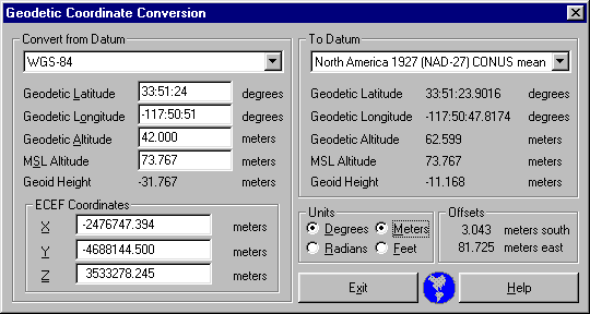

GeoConv is a Windows program which converts between the multitude of various geodetic coordinate systems which are used to represent the position of a point in the vicinity of the earth. More than 200 geodetic datums exist to describe position in local areas or over the entire earth.
The input position can be specified by its geodetic coordinates (latitude, longitude, altitude) or by its Earth-centered-earth fixed (ECEF) coordinates in the input system. Altitude can be expressed either as geodetic altitude above the ellipsoid, or as height above mean-sea-level. Input and output angular quantities can be specified in degrees-minutes-seconds, or in radians, and linear quantities can be expressed either in meters or feet.
The download file is the program executable. Download it to your hard disk and invoke it by double-clicking the executable or a shortcut to it.